 Polish Polar DataBase
Geoscientific information
Type of resources
Available actions
Topics
Keywords
Contact for the resource
Provided by
Representation types
Update frequencies
status
-
Glaciers facies (ice, superimposed ice, firn) extents of Hansbreen, Storbreen and Flatbreen delivered from unsupervised classifications of single, dual and fully-polarimetric SAR data (ALOS-2 PALSAR, RADARSAT-2, Sentinel-1, ERS-2 SAR) between 2008 and 2018. Methods of classification: unsupervised ISO classification, H-a Wishart Classification. Results validated with terrestrial measurements (shallow ice cores drilling, Ground Penetrating Radar measurements). Research supported by the European Space Agency, Third Party Missions grant and Svalbard Science Forum, Arctic Field Grant 2018. For more details, please e-mail to bbarzycka@us.edu.pl.
-
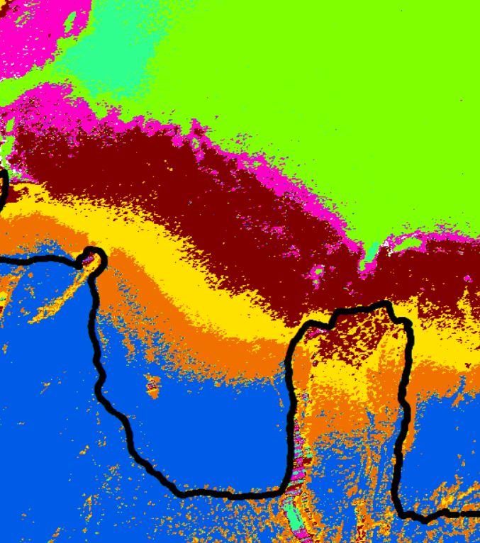
Glaciers facies extents of Langjökull delivered from unsupervised classifications of fully-polarimetric SAR data (ALOS-2 PALSAR, RADARSAT-2) for 2018 year. Date of SAR images acquisitions: 12, 16 Mar 2018 (Fine Quad Pol RADARSAT-2), 17 Mar 2018 (High Sensitive Quad Pol ALOS-2 PALSAR). Method of classification: H-a Wishart Classification. Results validated with terrestrial measurements (shallow ice cores drilling, Ground Penetrating Radar measurements). Research done with cooperation with University of Iceland and supported by the European Space Agency, Third Party Miassions. Overwiew of results of RADATSAT-2 (16 Mar 2018; Fine Quad Pol) classification of south part of Langjökull. Black line - contour of Langjökull; other colours - different scattering properties of SAR microwaves. For more details please contact Barbara Barzycka (bbarzycka@us.edu.pl).
-
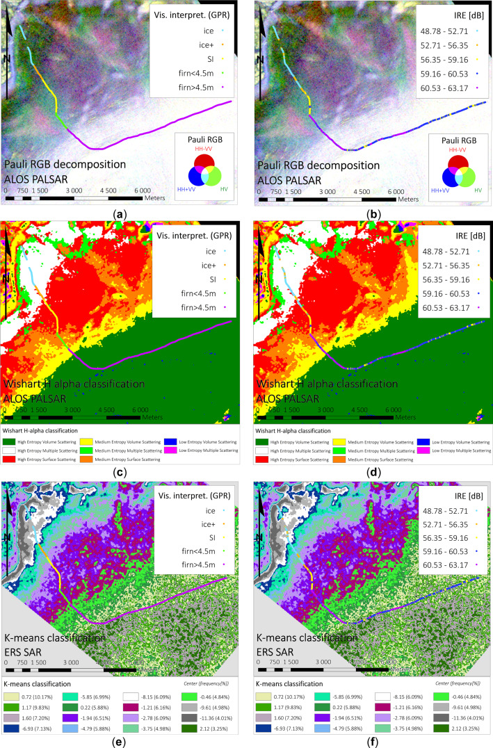
Glaciers facies extents of Vestfonna delivered from unsupervised classifications of SAR data (fully-polarimetric ALOS PALSAR, single polarimetric ERS-2 SAR) for 2009 year. Date of SAR images acquisitions: 4, 7, 20, 23, 26 May 2009 (VV Single Look Complex ERS-2 SAR), 22 May 2009 (ALOS PALSAR Single Look Complex 1.1, quad polarimetry). Method of classification: K-means classification, H-a Wishart Classification. Results validated with Ground Penetrating Radar data. For more information, please check: https://doi.org/10.1016/j.rse.2018.11.020 Overwiew of results of different classification methods with comparison to GPR data. Top panel: Pauli decomposition, middle panel: H-a Wishart classification, bottom panel: k-means classification. For more information, please check: https://doi.org/10.1016/j.rse.2018.11.020 (Figure 7).
-
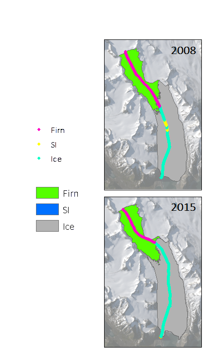
Firn extents of Hansbreen and Werenskoildbreen delivered from unsupervised classifications of single, dual and fully-polarimetric SAR data (ALOS-2 PALSAR, RADARSAT-2, Sentinel-1, ERS-2 SAR) between 2011 and 2017. Methods of classification: unsupervised ISO classification, H-a Wishart Classification. Results validated with terrestrial measurements (shallow ice cores drilling, Ground Penetrating Radar measurements). Research supported by the European Space Agency, Third Party Missions grant and Svalbard Science Forum, Arctic Field Grant 2018. For more details, please e-mail to this adress: bbarzycka@us.edu.pl.
-
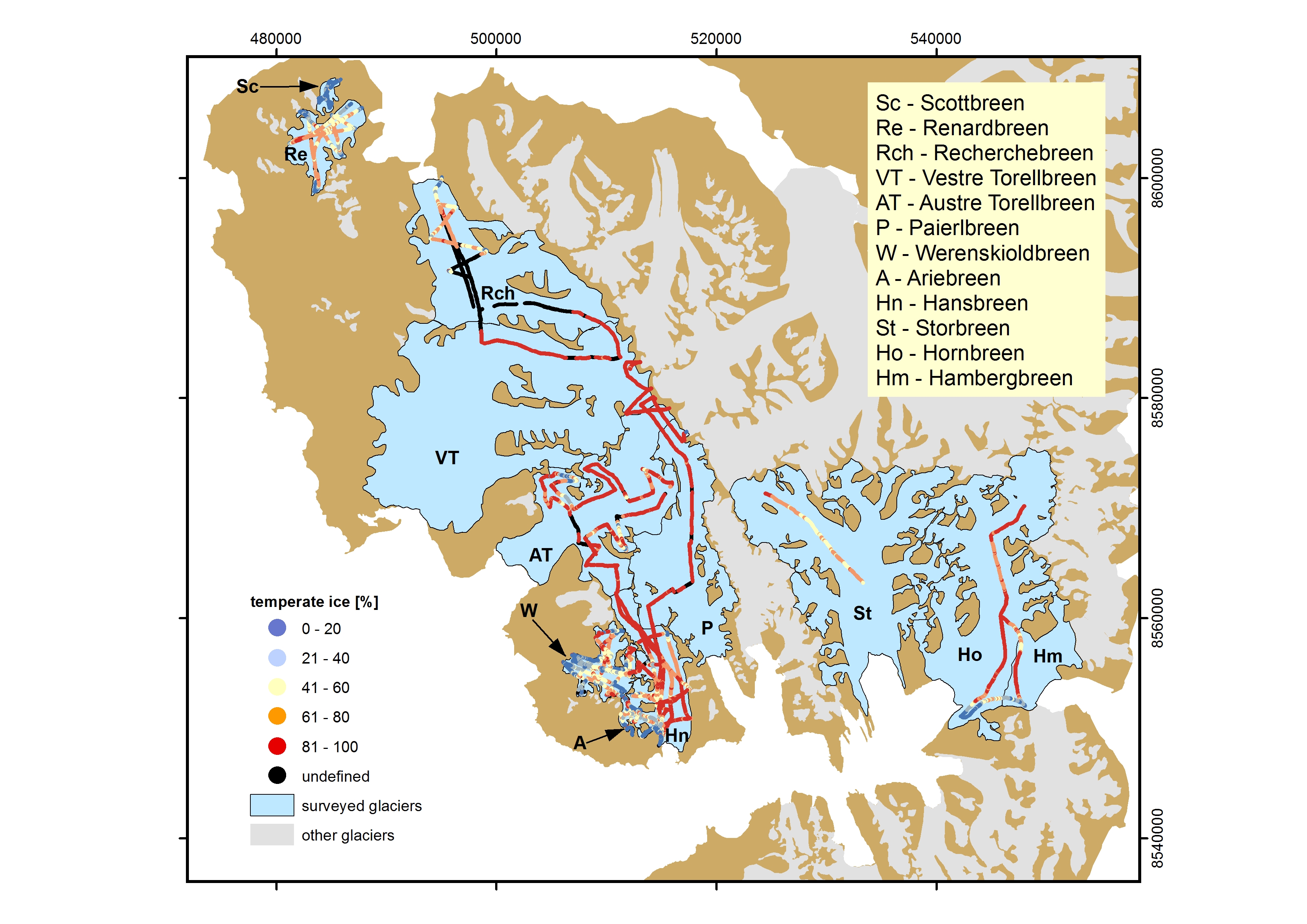
Thermal structure of selected S Spitsbergen glaciers was derived from ground based radio-echo sounding (RES). The division between cold and temperate ice layers is based on indirect interpretation of GPR (ground penetrating radar) image. Cold ice layer is virtually “transparent” for radio waves, while temperate ice layer is characterised by numerous diffractions on water inclusions. The database contains results from 479.7 km of RES profiles acquired in 2007-2014 on 12 glaciers in Wedel Jarlsberg Land and Torell Land (S Spitsbergen) including: Amundsenisen, Austre Torellbreen, Vestre Torellbreen, Hansbreen, Storbreen, Hornbreen, Hambergbreen, Recherchebreen, Scottbreen, Renardbreen, Werenskioldbreen and Ariebreen. Basic characteristics of investigated glaciers and its thermal structure is provided in table 1 (supplementary information). The surveys used GPR antennas in range 25-200 MHz, selected according to expected ice depth. Thanks to that on 87% of the profiles ice/bed interface has been identified. The radar system was pulled behind the snowmobile moving with velocity c. 20 km h-1. Applying trace interval 0.2-1.0 s, trace-to-trace distance was in range 1-5m. Trace positions were acquired by GNSS receivers working in navigation or differential mode with respective accuracy 3.0 m and 0.1m. RES data were processed applying standard filtering procedure (DC-offset, time-zero adjustment, 2-D filter, amplitude correction and bandpass filtering). Time-to-depth conversion used average radio wave velocity (RWV) for glacier ice 16.4 cm ns-1, 16.7 and 16.1 for cold and temperate ice respectively, based on CMP survey. More precise description of data collection, processing and quality is provided by Grabiec (2017). In S Spitsbergen polythermal glaciers are predominant. 57.8% of surveyed profiles consist of both: temperate and cold ice layers; 22.7% profiles is entirely temperate while 6.6% contains cold ice only (remaining profiles have undefined thermal structure). Studied glaciers represent broad spectrum of polythermal structure with cold-to-temperate ice ratio from 99:1% (Ariebreen) to 2:98% (accumulation zone of Vestre Torellbreen). The data were collected and processed under following projects: • IPY/269/2006 GLACIODYN The dynamic response of Arctic glaciers to global warming • UE FP7-ENV-2008-1 ice2sea Estimating the future contribution of continental ice to sea-level rise • PNRF-22-AI-1/07 AWAKE Arctic Climate and Environment of the Nordic Seas and the Svalbard – Greenland Area • NCBiR/PolarCLIMATE-2009/2-1/2010 SvalGlac Sensitivity of Svalbard glaciers to climate change • Pol-Nor/198675/17/2013 AWAKE-2 Arctic climate system study of ocean, sea ice and glaciers interactions in Svalbard area • 03/KNOW2/2014 KNOW Leading National Research Centre Reference: Grabiec M. 2017: Stan i współczesne zmiany systemów lodowcowych południowego Spitsbergenu w świetle badań metodami radarowymi. Wydawnictwo Uniwersytetu Śląskiego, 328 s.
-
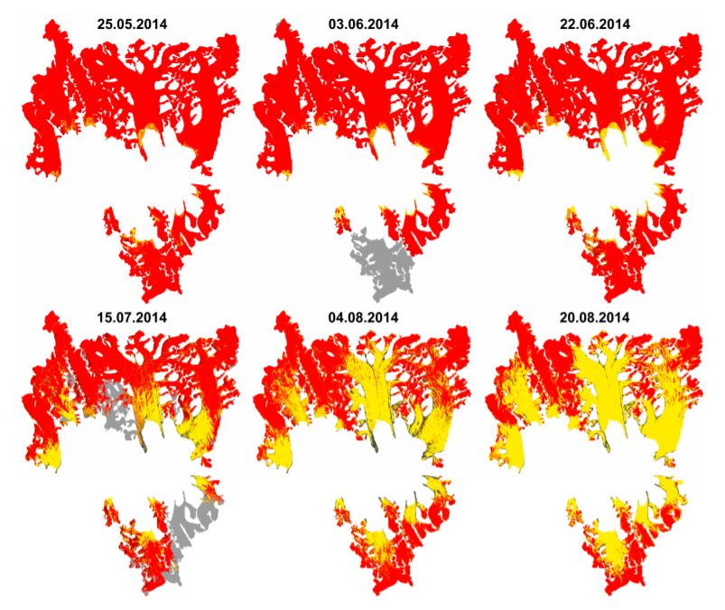
Results of supervised classification of six Landsat 8 images acquired on: 25 May, 3 June, 22 June, 15 July, 4 August and 20 August 2014, covering glaciers in Hornsund fiord. Method of classification: Maximum Likelihood. The results show variability of snow cover areas in melting period of 2014 for glaciers located in Hornsund fiord and larger than 9 km2 (Körberbreen, Samarinbreen, Chomjakovbreen, Mendelejevbreen, Svalisbreen, Hornbreen, Storbreen, Kvalfangarbreen, Mühlbacherbreen, Paierlbreen and Hansbreen). For more information, please check: https://doi.org/10.3390/w9100804 Overview: Results of Maximum Likelihood classification of Landsat 8 images for analysed glaciers. Red - snow cover, yellow - glacier ice, black - debirs, grey - cloud cover.
-
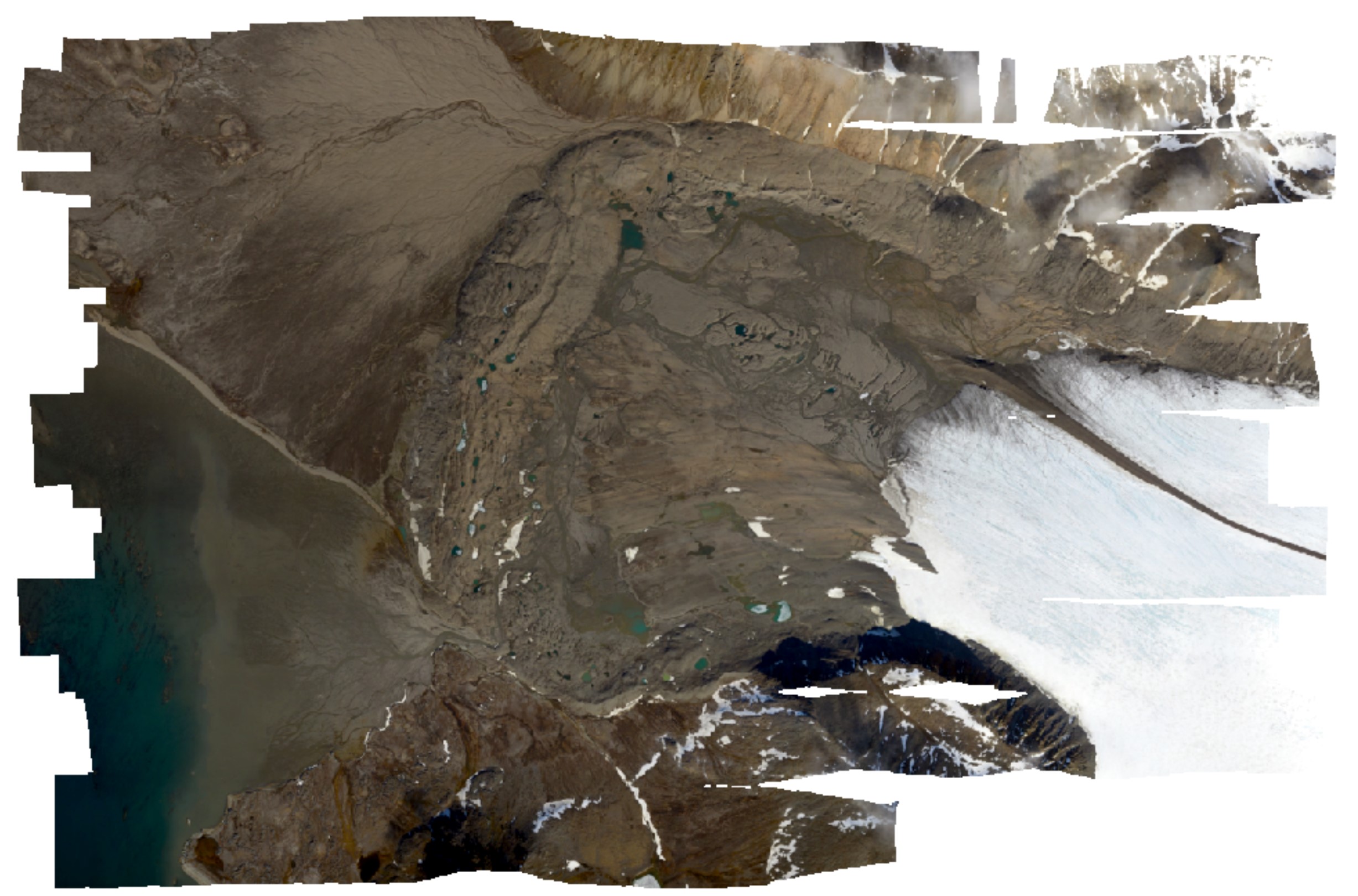
High-resolution orthomosaic derived from aerial images captured in 2020 over Hornsund, Svalbard by Dornier aircraft. The spatial resolution of the orthomosaic is 0.087 m. Aerial images for the area were provided by the SIOS through a dedicated call of proposals (https://sios-svalbard.org/AirborneRS). The dataset is the supplement to the paper: Błaszczyk, M.; Laska, M.; Sivertsen, A.; Jawak, S.D. Combined Use of Aerial Photogrammetry and Terrestrial Laser Scanning for Detecting Geomorphological Changes in Hornsund, Svalbard. Remote Sens. 2022, 14, 601. https://doi.org/10.3390/rs14030601
-
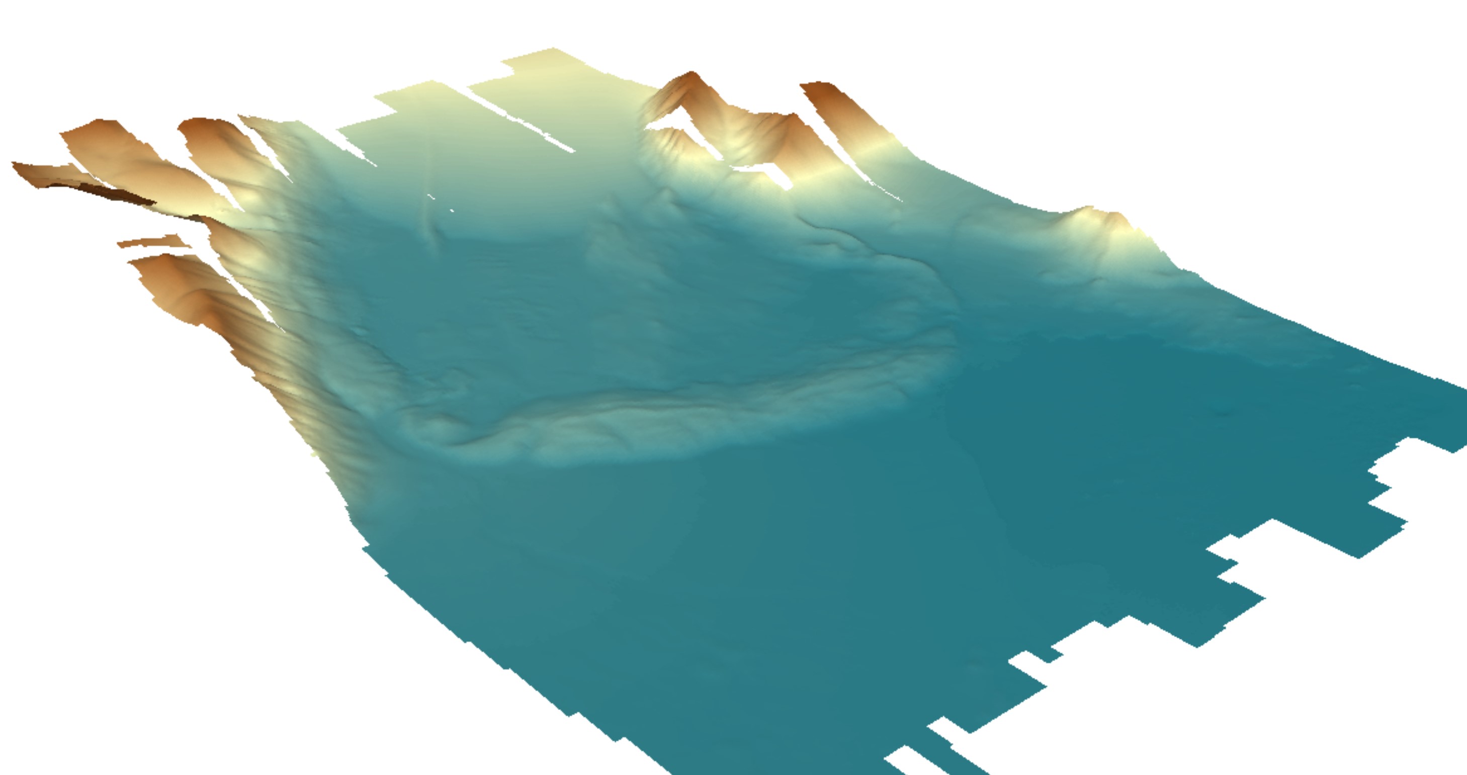
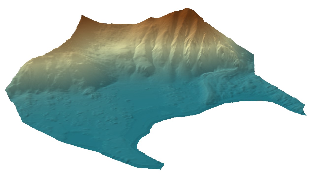
Digital elevation model (DEM) with high spatial resolution derived from aerial images captured in 2020 over Hornsund, Svalbard by Dornier aircraft. The spatial resolution of the orthomosaic is 0.174 m. Aerial images for the area were provided by the SIOS through a dedicated call of proposals (https://sios-svalbard.org/AirborneRS). The dataset is the supplement to the paper: Błaszczyk, M.; Laska, M.; Sivertsen, A.; Jawak, S.D. Combined Use of Aerial Photogrammetry and Terrestrial Laser Scanning for Detecting Geomorphological Changes in Hornsund, Svalbard. Remote Sens. 2022, 14, 601. https://doi.org/10.3390/rs14030601
-
Digital elevation model (DEM) combined from DEM derived from aerial images captured in 2020 over Hornsund, Svalbard by Dornier aircraft and from terrestrial laser scanner campaign in 2021. Both DEMs contain data gaps; therefore, they were combined to create a continuous product with the best possible accuracy and resolution. The dataset is the supplement to the paper: Błaszczyk, M.; Laska, M.; Sivertsen, A.; Jawak, S.D. Combined Use of Aerial Photogrammetry and Terrestrial Laser Scanning for Detecting Geomorphological Changes in Hornsund, Svalbard. Remote Sens. 2022, 14, 601. https://doi.org/10.3390/rs14030601
-

High-resolution orthomosaic derived from aerial images captured in 2020 over Hornsund, Svalbard by Dornier aircraft. The spatial resolution of the orthomosaic is 0.0843 m. Aerial images for the area were provided by the SIOS through a dedicated call of proposals (https://sios-svalbard.org/AirborneRS). The dataset is the supplement to the paper: Błaszczyk, M.; Laska, M.; Sivertsen, A.; Jawak, S.D. Combined Use of Aerial Photogrammetry and Terrestrial Laser Scanning for Detecting Geomorphological Changes in Hornsund, Svalbard. Remote Sens. 2022, 14, 601. https://doi.org/10.3390/rs14030601